Jeremy Bentham designed the Panopticon in 1791. A circular prison where a single watchman in a central tower could observe every inmate without them knowing whether they were being watched at any given moment. The genius was not the architecture. The genius was the psychology. Prisoners who assumed constant observation would regulate their own behavior. The watchman did not need to actually watch everyone. He only needed them to believe he could.
Bentham never built his prison. But the principle outlived him by two centuries.
Light Fighter Manifesto Volume IV: Unrest documented the modern version: “a clear and escalating arms race between the tactics of dissent and the technologies of state surveillance.” People who need to move through cities without being tracked on one side. A state that has responded with “a massive investment in a pervasive surveillance apparatus” on the other.
The apparatus is real. So are its blind spots.
The Ground Layer
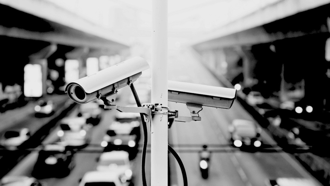
Atlanta holds a distinction that its tourism board does not advertise: it is the most surveilled city in the United States. For every thousand residents, there are 124 cameras watching. More than New York. More than Los Angeles. More than Chicago.
The number is not an accident.
The Atlanta Police Department runs Operation Shield from its Video Integration Center. The network pulls over 20,000 public and private camera feeds across the metro area. Gas stations. Parking garages. University security offices. Suburban HOAs. Ring doorbells. Traffic lights. Private cameras volunteered into a public network.

But the network is riddled with holes. Budget shortfalls have left a significant percentage dark at any given moment. Lenses pointed at nothing. Recording nothing. Connected to servers that nobody monitors.
Bentham’s watchman is asleep at his post more often than anyone admits.

The Flock Problem
Forget the fixed cameras for a moment. The faster-growing threat sits on poles at neighborhood entrances, highway off-ramps, and parking lot exits.
Flock Safety now operates in over 5,000 communities across 49 states, performing over 20 billion vehicle scans per month. Valued at $7.5 billion as of March 2025, the company leases access to its AI-powered tracking system rather than selling hardware outright.
Your vehicle photographed in Atlanta can be queried by a sheriff’s deputy in rural Texas.
Volume IV called it: “a searchable, time-stamped log of a vehicle’s movements, and by extension, those of its owner.”
| What LPRs Capture | Who Operates Them |
|---|---|
| License plate number | Police departments |
| Make / Model / Color | Sheriff's offices |
| Timestamp + GPS location | HOAs / Gated communities |
| Bumper stickers, damage, roof racks | Parking lots / Garages |
| Movement patterns over time | Private businesses |
Network sharing: Agencies on Flock's national network can search all 90,000 connected cameras. Your plate captured in one city is searchable by departments in another.
The network effect is the real threat. As more departments join, getting your own Flock system becomes more valuable because you gain access to everyone else’s data. The incentive structure guarantees expansion.
In October 2025, Flock announced a partnership with Amazon’s Ring. Law enforcement using Flock’s platform can now request footage directly from Ring doorbell owners. The same month, 404 Media reported on a Flock product called “Nova.” The system combines license plate data with information from data breaches, public records, and commercial databases. The goal: track specific individuals without a warrant.
Data retention defaults to 30 days. But once flagged in an investigation, that data can be preserved indefinitely. The cameras do not capture faces. They capture something more useful: patterns. Where you go. When you go there. How often. What route you take.
Over time, the system learns your routine better than you know it yourself.
The courts are testing the boundaries. In June 2024, a Norfolk, Virginia circuit court judge ruled that Flock data collection constitutes a search under the Fourth Amendment, suppressing evidence from the city’s 172 cameras. However, the Virginia Court of Appeals later reversed that decision, joining courts in multiple states and the Ninth and Eleventh Circuits that have found fixed-location ALPRs constitutional. The Institute for Justice filed a federal lawsuit against Norfolk PD in October 2024, arguing Flock surveillance violates constitutional protections. That case is ongoing.
A grassroots project called DeFlock has begun mapping these cameras. As of late 2025, volunteers have logged over 16,000 Flock camera locations worldwide. The project’s creator received a cease-and-desist letter from Flock Safety. The EFF told them to pound sand.
The map is still growing.
Crowdsourced Flock camera locations. See what is watching your neighborhood, your commute, your patterns. Contribute sightings to the database.
deflock.me/mapEFF’s Atlas of Surveillance documents police surveillance technologies across the United States. Search by city, county, or technology type.
atlasofsurveillance.orgThe Air Layer
The ground cameras are obvious. The aerial surveillance is not.
The FBI operates more than 100 surveillance aircraft registered to shell corporations with post office boxes in Bristow, Virginia. Most are single-engine Cessna 182T Skylanes, fitted with exhaust mufflers to reduce engine noise, flying at approximately 5,000 feet. The cameras resolve individual faces on the ground. Many aircraft also carry cell-site simulators capable of forcing every phone in range to connect and identify itself.
In one documented case, federal prosecutors admitted the FBI used its Cessna fleet to surveil a subject for 429 continuous hours over 24 days without ever obtaining a warrant. The subject had no idea he was being watched from above.
The FBI maintains that its fleet is “not equipped, designed or used for bulk collection activities or mass surveillance.” The AP reported that the FBI “occasionally” uses IMSI-catchers on the aircraft. The word “occasionally” is doing a lot of work in that sentence.
Beyond the FBI’s Cessnas, wide-area motion imagery systems represent the next evolution. The military developed these under the program name “Gorgon Stare” for battlefields in Iraq and Afghanistan. Multiple sensors track every vehicle and person moving within an entire city. Simultaneously.
Baltimore tested such a system. A company called Persistent Surveillance Systems flew camera-equipped aircraft over the city at least 40 hours per week. The cameras recorded slow frame-rate video that let police track anyone’s movements backward through time. Pick a location. Pick a moment. Follow the target wherever they went.
The Fourth Circuit Court of Appeals ruled the program unconstitutional in an 8-7 decision. The court found that “persistent surveillance of outdoor movements invades people’s reasonable expectation of privacy.” Baltimore terminated the contract.
Other cities are watching the legal landscape before deploying similar systems. The technology exists. The precedent is contested. Expect this fight to continue.
The RF Layer
Court records have confirmed widespread use of IMSI-catchers by both federal and local law enforcement. By mimicking a cell tower, these devices force every phone in range to connect, logging its unique identifier without the user ever knowing.
The global IMSI-catcher market reached $190 million in 2024. Police departments, intelligence agencies, and national security operations are all buying.
The Baltimore Police Department used Stingrays 4,300 times between 2007 and 2015. A dozen federal agencies deploy them, including the FBI, NSA, DEA, ICE, and all branches of the military. At least 25% of law enforcement agencies have used “tower dump” data collection, and at least 25 police departments have purchased Stingray equipment outright.
Your phone betrays you constantly. It announces its presence to every cell tower within range. It logs your location even when you think it is off. The baseband processor handles all cellular communication. This chip operates below the operating system. You cannot control it. You cannot audit it. You can only trust that it is not being used against you.
That trust is misplaced.
IMSI-catchers also disrupt emergency calls. A device forcing phones to connect to a fake tower can prevent 911 calls from reaching real infrastructure. The surveillance tool becomes a public safety hazard.
Some states now require warrants for Stingray use. Virginia, Washington, California, Minnesota, and Utah have passed laws. The Cell-Site Simulator Warrant Act of 2021 tried to establish a federal standard requiring probable cause. Enforcement remains inconsistent.
The only reliable defense is not carrying a phone at all, or carrying one that cannot connect to cellular networks.
The Fusion Problem
All this data flows somewhere. Seventy-nine federally designated fusion centers nationwide. DHS grant money has helped them purchase predictive policing systems from Palantir and social media surveillance software from Dataminr. These centers were built for counterterrorism coordination. They have become clearinghouses for domestic intelligence collection.
Palantir’s Gotham platform connects datasets that were never meant to talk to each other. Analysts can build profiles and search for individuals by tattoo, immigration status, or known associates. DMV files. Police reports. Subpoenaed social media data. Location history. Private messages. All searchable. All connected.
The Trump administration expanded Palantir’s federal footprint significantly in 2025. The Department of Defense awarded the company a $795 million contract that could grow to $1.3 billion for data fusion and AI programs across the military. Palantir’s Foundry software now runs at DHS, HHS, FDA, CDC, and NIH.
The state has built a near-perfect system for monitoring public gatherings. It has mastered the art of identifying participants and prosecuting them. An overwhelming asymmetry of information.
That is the threat. Now consider how to move through it.
Into the Kill Zone
The most dangerous moment comes first: entering the city.
Every highway off-ramp has license plate readers. Every commercial corridor is lined with storefronts whose cameras feed directly into the VIC. Every gas station, every drive-through, every parking lot creates a timestamped record of your presence.
The traditional approach treats these routes as inevitable. The light fighter approach treats them as kill zones.
Consider instead the spaces that cameras do not watch.
Beneath Atlanta’s streets lies a network that most residents have never seen. Storm drains wide enough to walk through. Utility tunnels carrying fiber optic cables and water mains. Disused railway lines running through the industrial zones south of downtown.
Urban exploration communities have documented these passages for years. Mapping them. Photographing them. Posting their findings online for anyone willing to look.
The tunnels flood. They smell like what you would expect. They are not comfortable.
They are also almost entirely unmonitored, because cameras cost money and nobody expects you down there.
Municipal infrastructure records are often available through FOIA requests. City planning departments publish more than they realize. The information exists. It simply requires someone willing to read boring documents.

Becoming Invisible in Plain Sight
The man who stepped off the MARTA train at Five Points at 2:47 p.m. on a Tuesday had studied what people in Atlanta actually wear. He spent three weeks on the research before his arrival.
He used Google Street View to examine pedestrians frozen in time on Peachtree Street, on Auburn Avenue, in the parking lots of shopping centers in Buckhead. He scrolled through Instagram posts geotagged to the neighborhoods he planned to move through.
He watched. He noted. He learned.
He did not wear 5.11 tactical pants. He did not wear Salomon trail runners. He did not carry a pack bristling with MOLLE webbing and carabiners.
He did not, in other words, look like the kind of person who reads articles about tactical operations in surveilled cities.
He looked like a man going to work.
Public transit exists, from an operational perspective, as a kind of anonymizing bath. MARTA stations at Five Points and Lindbergh Center process thousands of faces per hour. You are not a person in that flow. You are a data point, indistinguishable from the mass of other data points moving through the turnstiles.
Move with the crowd, not against it. Dress like the crowd dresses. Carry what the crowd carries. Walk at the speed the crowd walks.
The surveillance system is optimized to detect anomalies.
Do not be one.
Recoding Space
An observation post is not about finding the perfect position from a video game. It is about recoding space. Taking something that already exists in the urban environment and making it serve a purpose it was never designed for.
Without changing its appearance.
The construction tarp covering a renovation project. The commercial advertising banner hanging on a fence. The discarded furniture piled in the corner of an abandoned lot.
These things are invisible because they belong. Nobody questions what belongs.
Materials brought in from outside draw attention. Materials already present draw none.
A broken section of wall in an abandoned factory is not damage. It is a loophole created by time and neglect. A firing position that looks exactly like what surrounded it before you arrived.
A rusted panel on an industrial silo. A gap in corrugated metal fencing.
The city is full of voids. The operator’s task is to see them.
The Geometry of Loopholes
Stop looking at buildings as solid structures. Start seeing them as Swiss cheese.
Shooting through glass is not viable. Deflection is unpredictable, and the signature creates immediate compromise. Focus on apertures that already exist.
Weep holes appear in brick facades every two to three feet. Small drainage openings, three-eighths to half an inch wide. Ventilation slats cover HVAC systems on commercial buildings, their angled fins creating narrow but usable sight lines. Gaps appear in cinder block construction wherever builders cut corners.
Drainage culverts run beneath roadways, their openings varying from four inches to more than a foot in diameter.
These features exist at varying heights. They are not perceived as threats. They were put there by city contractors who never imagined their work would be analyzed this way.
The space between parked cars forms temporary lanes of fire. The shadowed area beneath a truck chassis offers a low-angle position that is nearly impossible to spot from any distance. A hole cut in the opaque panel of a commercial van transforms it into a mobile hide.
The city is already falling apart. Use what it provides.
Reading the Nervous System
Before movement comes mapping. Every operation depends on understanding both the physical terrain and the digital layer on top of it.
Flat maps lie. They conceal elevation changes, natural depressions, building-induced blind spots that only become visible in three dimensions.
Google Earth Pro provides free access to 3D terrain data and historical imagery. OpenStreetMap offers building footprints and infrastructure data. Thousands of volunteers have mapped features that official sources never recorded. The National Pipeline Mapping System reveals where utility tunnels run beneath the streets.
Every city has rhythms. Learning them is reconnaissance.
A major event at Mercedes-Benz Stadium does not simply create traffic. It creates predictable chaos. Concentrations of police resources. Diversions of public attention. Masses of pedestrians that can serve as cover or obstacle depending on how you use them.
Foot traffic analytics platforms publish data openly. Event calendars reveal when those masses will form and where they will flow.
Flightradar24 tracks aircraft in real time, including law enforcement helicopters and those FBI Cessnas circling overhead. The shell company registrations are known. The tail numbers are documented. You can watch the watchers. Broadcastify provides access to public safety radio traffic. Scanner feeds that reveal where police are responding and where they are not.
Social media surfaces the rest. Traffic accidents. Protests. Police activity.
The city narrates itself constantly, to anyone willing to listen.
The Dirty Secret
Here is what the city’s surveillance advocates would prefer remained unspoken.
A significant percentage of the cameras do not work.
Budget shortfalls. Maintenance backlogs. Integration failures between legacy systems and newer installations. Exposed wiring and dead feeds and servers that have not been rebooted in months.
The areas with the least public investment tend to have the most unreliable coverage. The panopticon is a paper tiger in certain neighborhoods. Not everywhere. Not reliably.
But somewhere, at any given moment, the system is blind.
Knowing where requires patient mapping and observation. Knowing when requires accepting that certainty is impossible and acting anyway.
Bentham’s Ghost
The state cannot actually watch everyone all the time. It does not have the personnel, the budget, or the technical capability. But if you believe it can, you regulate your own behavior. You stay home. You stay quiet. You stay still.
Over 20,000 integrated camera feeds in Atlanta. Fifty thousand Flock LPRs performing 20 billion scans per month nationwide. FBI aircraft overhead. Stingrays in the RF spectrum. Fusion centers correlating it all.
But the system has blind spots. Maintenance failures. Legal vulnerabilities that courts are beginning to exploit. The tunnels go unmonitored. The crowds provide cover. The city’s own decay creates the loopholes you need.
Bentham never built his prison. The modern state built something close. But the watchman is not all-seeing. He only needs you to believe he is.
Stop believing.
Sources
- Comparitech: “CCTV surveillance in the most populated cities in the United States” (January 2024)
- Atlanta Police Foundation: Operation Shield Program
- Atlanta Magazine: “Atlanta’s surveillance network keeps growing” (2024)
- Flock Safety: Wikipedia
- NBC News: “Flock police cameras scan billions per month, sparking protests” (2025)
- TechCrunch: “Amazon’s Ring to partner with Flock” (October 16, 2025)
- 404 Media: Flock Nova product development reporting
- Virginia Lawyers Weekly: “Automatic license plate reader data suppressed” (June 2024)
- Virginia Court of Appeals: Commonwealth v. Bell reversal
- Institute for Justice: Norfolk ALPR Fourth Amendment lawsuit (October 2024)
- Associated Press via PBS: “FBI behind mysterious surveillance aircraft over U.S. cities” (2015)
- ACLU: Baltimore aerial surveillance program ruling (Fourth Circuit)
- Business Research Insights: IMSI Catcher Market Report (2024)
- EFF: Cell-Site Simulators documentation
- DefenseScoop: “DOD raises Palantir’s Maven contract to more than $1B” (May 2025)
- Light Fighter Manifesto Volume IV: Unrest (Light Fighter Manifesto L.L.C., 2024)
Sources verified January 28, 2026